|
(3) Lethbridge -
Niagara

After 3 days of Wonderful Rocky mountains driving,
2,087 miles of driving between Lethbridge and Niagara Falls
was the worst section to drive during this trip. This is central
plain of the North American Continent and there is nothing much to see but a
flat plains. It is same in the United States side too between Denver and Chicago -
just a flat plains of farmimg fields without even a high hill.
ˇˇ
Day-7
(8/21) : Lethbridge - Regina Trans-Canada
Highway-1 was real "Freeway" between Vancouver and Calgary with
ramps to enter and exit, without any road crossing the Highway-1. However,
when we returned to Highway-1 at Medicine Hat from local highways to/from
Waterton National Park, I found it is not a "Freeway" but a normal
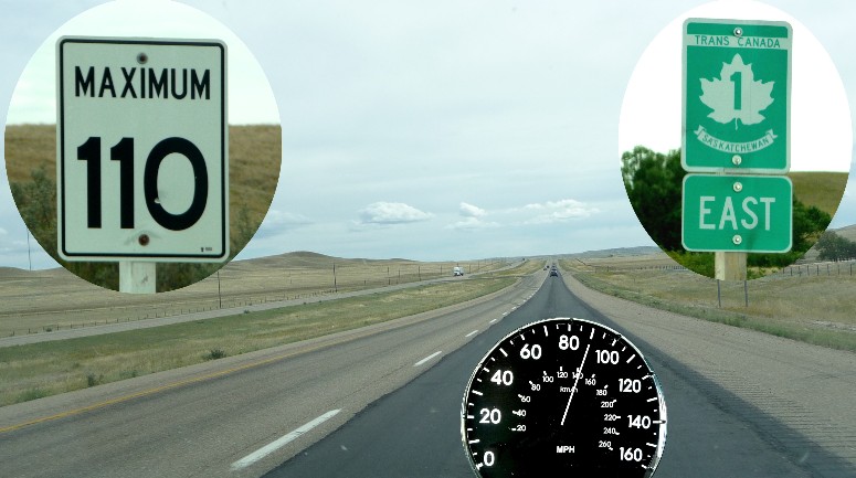
farm land highway with frequent crossing roads and signals at cities. The
speed litmit was 100 - 110 Km (60 - 65 MPH) at most part of the road but
some cars and even farming tractors crossed this Highway-1. The only reason
the speed limit can be as high as 110Km/hour is "There are not many
cars" on TRANS-CANADA HIGHWAY-1, as shown picture below. During
most of the day of driving, we did not see any more than 10 cars on both directions together at
a time at this wide open flat land Highway-1 where
you can see quite far a way. Some times we counted less than 5 cars as far
as we could see in front and back altogether. Therefore, the road was practically same as
"Freeway" (actually, far better wide open Freeway) and I drove 80
MPH (130Km/H) most of the day and sometimes 90MPH (145 Km/H).
(Please do nto report to Canadian Police untill I get out of Canada on 8/29
!!!) I don't
think there is any patrol car patrolling in this wide areas with such a
few cars on the road. (I have not seen any.) The
"Trip Maker" software calculated it will take 7.5 hours of actual
driving time, but it really took little more than 5 driving hours only for 384 miles to get to Regina from
Lethbridge. Crazy driving? Agree!! But there was no car around
us most of times
and it was 2 lanes road all the way.
There
were many many crossing roads (100-200 yards apart many places) on
Trans-Canada Highway-1.
ˇˇ
Day-8
(8/22) : Regina - Winnipeg
The
weather had been cooperating very well untill yesterday and we had no major
weather problem. However, the situation was quite different this morning.
The heavy rain started from the night and continued to the morning. When we
left hotel in Regina at 9:00 AM, it was heavy and I could not drive any
faster than 60 MPH for about 20 min.. Then, it became slowly lighter, but
occasionally still heavy, untill 10:00 AM. It really started to clear from
10:00 AM and we could have blue sky with some clouds without any rain after
11:00 AM fortunately. In
the early morning, it was really hard driving. I could not dare to pass any
car, even trucks or campers. I just followed them. However, I could slowly
speed up from 10:00 AM and returned to normal (?) speed of 80 MPH from 11:00
AM.
There
were little more cars on the road than yesterday but still 10 - 20
cars at the most we can see at a time. It seems Canadians are following the
speed limit very well generally and they were mostly driving at the speed of
100-110 Km/h, maximum speed within speed limit, while this crazy California driver was passing almost all of
them at the speed of 130-140 Km/h (80-85 MPH) for whole day. (Again, no
report to Canadian Police, please !!)
The
time was supposed to be changed yesterday when we got into Saskatchean from
Alberta, as the time zone was changed from Mountain Daylight Saving Time to
Central Daykight Saving time. However, we found Saskatchean did not adopt Daylight Saving Time
and time was same in Regina without change. Instead, today, when we got into
Manitoba, the time was 1 hour ahead as it was Central Daylight Saving
Time.
We will have another time change tomorrow when we arrive Thunder Bay, from
Central Daylight Saving Time to Eastern Daylight Saving time. We left Regina
at 9:00 AM and arrived Winnipeg at 4:00 PM local time after driving
348 miles which sounds like we drove exactly as planned. However, we
actually arrived 1 hour earlier than plan, because no time change was
expected in the plan and 4:00PM in Winnipeg was 3:00 PM of Regina time.
Winnipeg
at the just about center of Canada (East-West wise) is the city of the
famous "Winnie-the-Pooh", which name came from the city name of
Winnipeg. Flat
central plains of Canada, just like central plains in U.S.A..
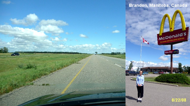
We had lunch
at McDonald's frequently which large yellow M sign makes easiest to find
from far a way while driving at high speed and had in Brandon, 120 miles to Winnipeg,
too. Taco Bell was another faverite as Jane likes Taco, though we visited
KFC, A&W, Subway etc also whichever we can find first. There are far less
fast food restaurants along the Highway-1 in Canada than U.S. and you will
not see again for more than an hour at least (sometimes almost 2 hours) if you miss one.
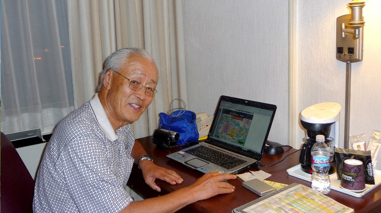
Connecting
to internet, checking e-mail, reading internet newspaper, transfering
pictures and videos taken the day from cameras to notebook computer,
arranging web site data and uploading to thechofamily.com and choand2 at a
hotel room desk. Not only daytime for driving, every evening is also busy time. No time to rest untill bed
time !!! From 3-4 AM untill Jane gets up in the early morning is also my
computer time for this early bird !!!
Day-9
(8/23) : Winnipeg - Thunder Bay We
drove 422 miles from Winnipeg to Thunder Bay today leaving Winnipeg at 9:00
AM and arriving Thunder Bay at 6:15 PM - just about 15 min. delay from the
plan. (Considering time zone change, it was 8 hours 15 min. of travelling
time including lunch/break times.) The weather was cloudy with drizzle on
and off for whole day. It didn't bother the driving much except we had to
turn the windshield wiper continuously on and off for almost whole day. It finally cleared around
5:00 PM when we were only about 1 hour to the destination. After
we left Winnipeg, in less than an hour, we got in to the Province of Ontario
and the road was changed from Trans-Canada Highway-1 to Highway-17 which was
the single lane road all the way with passing lanes here and there. The
Canadian passing lane is much much longer than passing lanes in U.S.
highways (some times more than a mile)and you can pass quite many cars. Besides, since there are not too
many cars, you can also pass easily and safely at dotted center lane sections. The
road was continuously curving with many tall trees at both sides blocking vision,
different from wide open flat central plains. It was also always up
and down hills, not much high hills but low hills - similar to eastern part
of U.S.. However, more than anything, there were so many lakes - at road
sides too. I think we saw more than 20 large and small lakes at both sides
of road. With these many lakes, there were lot of recreational areas and
resorts according to the road signs. The
speed limits were 110 Km/h between Lethbridge and Regina mostly, 100Km/h at
the highest between Regina and Winnipeg but 90Km/h in Ontario. Would it be 80Km/h in
next provinnce and 70Km/h in the following province ?????? The
road signs were much more friendly with lot more frequent road signs and speed
limit signs. The number of cars were still not
too many, but there were lot more cars in Ontario, 2-3 times more than
previous provinces. Another change noticed was we saw 3-4 highway patrol
cars in Ontario - for the first time since we left Vancouver, though they
seem to be patrolling only within 20-30 miles from the cities. At
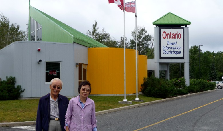
the Ontario Travel Information Center right after province border.
So many lakes in
Ontario. If you include small lakes not shown in the map, there might be
thousands. 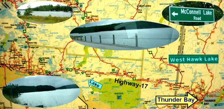
Highway-17 in
Ontario. Continuous up and dow and curbing road with single lane only. Many
tall trees on both sides.

ˇˇ Day-10
(8/24) : Thunder Bay - Sault Ste Marie We
drove 432 miles again, just 10 miles more than yesterday, and arrived Sault
St. Marie at 6.20 PM. The hotel gave us a room with great view of Lake
Superior and we could see Michigan State of U. S. A. on the other side of
the lake only a half mile away. (There was a bridge to cross to U.S. very
close from the hotel.) The weather was
generally clear with some clouds whole day but it was much more windy.
Road was same as yesterday with single lane only, but more hilly generally. There were lot more
cars on the road near Thunder Bay but became normal Canadian traffic in the
afternoon as we drove away further and further from big city (Thunder Bay) -
no car on the road but us quite frequently. There
were more lakes on both sides of Highway-17. I believe we saw several 10s of
lakes, small and large, in addition to the Lake Superior on the right for
whole day. We could see great view of this giant lake on and off during the day. Jane
watching the huge Lake Superior which looks like an Ocean.
 View
of Michigan, U. S. A. from hotel room window. Good swimmer might be able to
swimm to cross the lake. Day-11
(8/25) : Sault Ste Marie - Niagara Falls After 5 days of
boring
drive - nothing especially to see and no one to meet - we have
crossed Canada finally and arrived Niagra Falls on 8/25, the 11th. day of
the trip, at around 6:40 PM driving 501 miles on the day. Up to here, we have driven total of
3,972 miles
since we left home, which is just about 1/3 of the planned
33 days of the trip. It
was a long day for us having a various problems. Last evening, both of us
ate too much dinner and both didn't want to have early breakfast. However,
we had a dinner reservation at Skylon Tower revolving restaurant in Niagara
at 7:00 PM. Not to be late for the dinner reservation time, we wanted to
leave little early today. Therefore, we diceded to leave hotel early without
breakfast and take a breakfast later on the road. We
left Sault St. Marie hotel at 7:40 and set the navigator for Niagara.
However, there are two routes to go to Niagara - one is continue to take
Highway-17 in Canada and another route to cross the border, drive
Michigan, U. S. A. and get back to Canada at almost to Niagara Falls, Canada. I
wanted the first choice because the driving Canada was the primary purpose
of this trip. Well,
it looks like the navigater didn't like my idea. It led us to Canada-U.S.A.
border through strange roads and we were lost again. We stopped car, turned
notebook computer on, looked at the map program and found the way to return
to Highway-17. We found the sign to Hiway-17 and started to follow it. However,
what a great way to get out of a city!!! The
road signs to Highway-17 on the streets led us to east, then to north, then east, then south, and west next, then to
south again..... all kinds of directions. We just followed road signs to
Highway-17 but drove around the city to all directions just to get out of this not too large
city and finally hit Highway-17 after 30 min. of driving around the city.
The navigator was still asking me to make U-Turn and go to the U. S. A.
border even after we drove more than 1 hour on Highway-17. It started to
show right way finally after I turned it off, restarted and reinputted the
destination of the day - Niagara. So,
the day started problems of stubborn navigator and wonderful road signs (or
roads ?) in Sault St. Marie city. We took a breakfast on the road later and
drove smoothly untill we hit the Toronto.Wow!! What a wonderful city the
Toronto city is with 2.5 million populations according to the road sign. I
have never seen such a traffic jam on the freeway in my whole life. It was
continuous stop and go for about one and half hours just to pass the
outskirt of the city, not the center of the city, even though it was a rush
hour. We had to call Skylon Tower restaurant to delay our reservation from
7:00 PM to 8:00 PM with cellular phone and we finally arrived the hotel at
6:40 PM - 40 min. later than planned in spite of 1 hour 20 min. earlier
departure than planned, and 11 hours on the road today. Out of this 11 hours, more than two hours were waist of the
time on the road. What would it happened if we left hotel on time as
planned? sometimes, it looks like too much dinner also helps you??? Great !! During
the last 5 days of drive, it was mostly boring long drive every day.
However, I think it was worthwhile to learn many things about the Canada -
nature, country and people. What we have learned were : Canadians
seem to be very patriotic. There are so many Canadian national flags
everywhere - shops, restaurants, gas stations, on the streets, even some
prive residents - sometimes with Stars and Stripes, sometimes Union Jack too
-
a lot more than national holidays in U. S. A. or in Korea.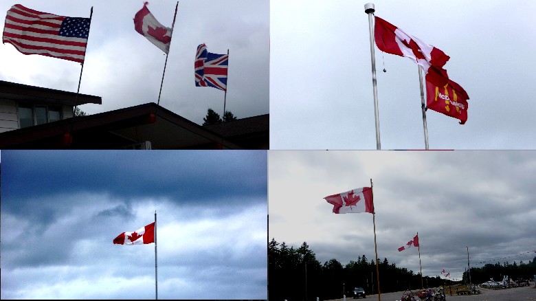 We
saw almost no oriental or black in any cities along the road other than
large cities like Vancouver. I expected some former Hong Kong Chineses at
least, as many of them have immigranted to Canada. It seems they all live in
big cities only.
Signal system was strange. Green signal was flashing from the start all the
way at many cities, but not all cities. some times, yellow light was flashing too
and I didn't know what to do. Later, I learned the flashing doesn't mean
anything special. You may just consider them as normal green or yellow
singals. Red signal always stayed on. It seems traffic signal system is not
uniform throughout the whole Canada but little different by province. Regular
gas price is about $5.00 a galon (C$ 1.35 per liter), a lot higher than U.
S. Central
part of Canada is very similar to the central plains in U. S. A.. Flat and
wide
open. Ontario is very beautiful province with continuous hills (but no high
mountain), a lot of beautiful tall trees, many many lakes and it is
really a huge province (It took 3 full days of 450 - 500 miles daily
driving from Manitoba-Ontario border to Niagara which is still Ontario.) and
very similar to eastern part of U. S. A., but with so many lakes everywhere
- huge, large, small. Just
a few I have noticed, but learned a lot more about Canada. ˇˇ Niagra
Falls, 8/25 We checked in at Holiday Inn at Canadian side, very close to the Canadian
Falls, and we could have best view of all three falls just walking a block to the Niagra Parkway
easily.. 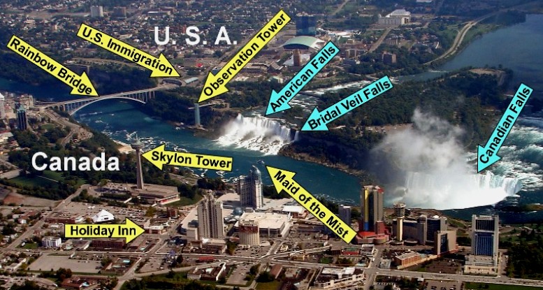
I wonder whether there is anyone who has lived long enough in U.S. or has visited
eastern U.S.A. from Korea, but has never been to Niagara yet. However, I wonder also whether
everyone who has visited Niagara has seen Niagara at Canadian side.
If not, you
better try next time. Real view of Niagara is much greater at Canadian side.
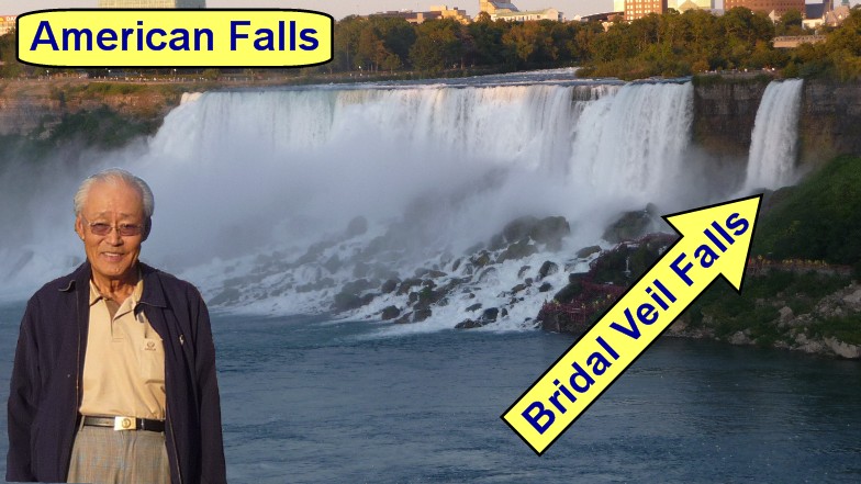
You can see falls much closer at Canadian side and the Canadian Falls (or
Horseshoe Falls) is much larger than the American Falls. From U. S. side, You
can not see even American Falls close enough and what you see is just a
side views only of all the falls. When we visited
Niagara for the first time in 1975 during our Family Trip crossing U.S.A.,
we were waiting for permanent visas of U.S.A. and stayed in the U.S. without
visas but with petitions from legal point of view, because our existing visas were all cancelled as soon
as we applied permanent visas. (We could stay in U.S. as Permanent Visa
Applicants waiting for the Permanent Visas.) Therefore, when we asked whether we can cross
the Rainbow Bridge to the Canadian side, the immigration officer said
"You are not a American citizen and we have no authority to stop you
crossing the border. However, you have no right to come back to the U.S.A.
as you don't have a visa to U.S.A." At
that time,
my sister Dong-Hyun livied in Toronto and we were going to meet at Niagara.
Because we couldn't cross the border, her family cross the Rainbow Bridge
and we met at American side. Instead, we took the tour boat
"Maid of the Mist", which sailed partially to Canadian side
too, as the border line was the middle of the river. (This sightseeing boat
departs from both sides and you can approach close enough to the Canadian
Falls. - You will be very wet, though they provide you a rain gear.) 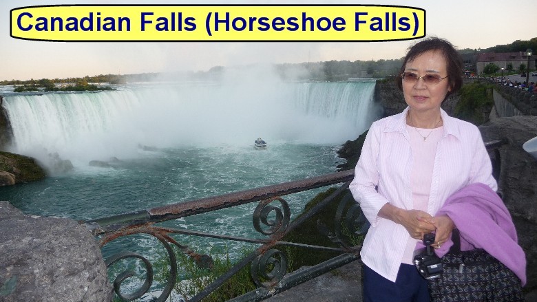
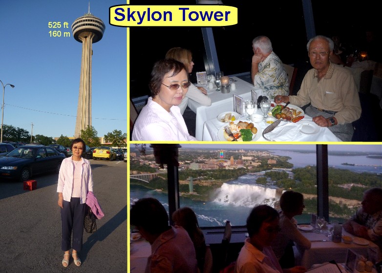
We
had a great dinner at 525 ft high revolving restaurant of the Skylon Tower
rotating one round every hour, overlooking spectacular night view of Niagara
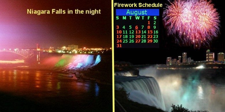
Falls and all Niagara area while having dinner. When it gets dark at around
9:00 PM, They started to iluminate the falls changing colors of red, blue,
yellow and green.
They have fireworks 3
times a week in Summer (July & Aug.) which we have missed this time by just
one day unfortunately.
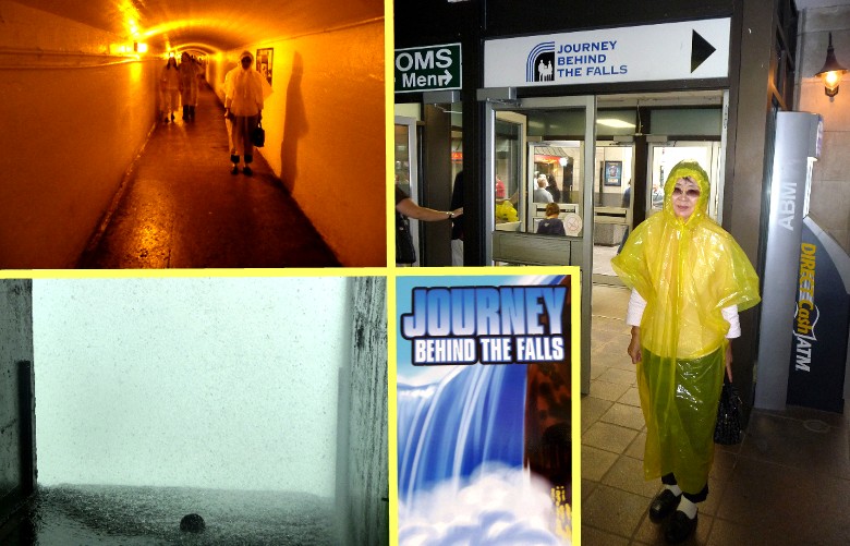
Next
morning before we leave Niagara Falls for Ottawa on 8/26, since we had the "Maid of the
Mist" boat sailing in 1975, we didn't take it this time but joined
"Jouney behind the Falls", which is : You take an elevator to go
down about 150 feet, walk a tunnel behind the Canadian Falls and watch the
falls right behind the falls.
However,
this was really disappointing. There were two openings of the tunnel to see
the fall from behind, but all we can see was something like dense fog, not
the water fall.
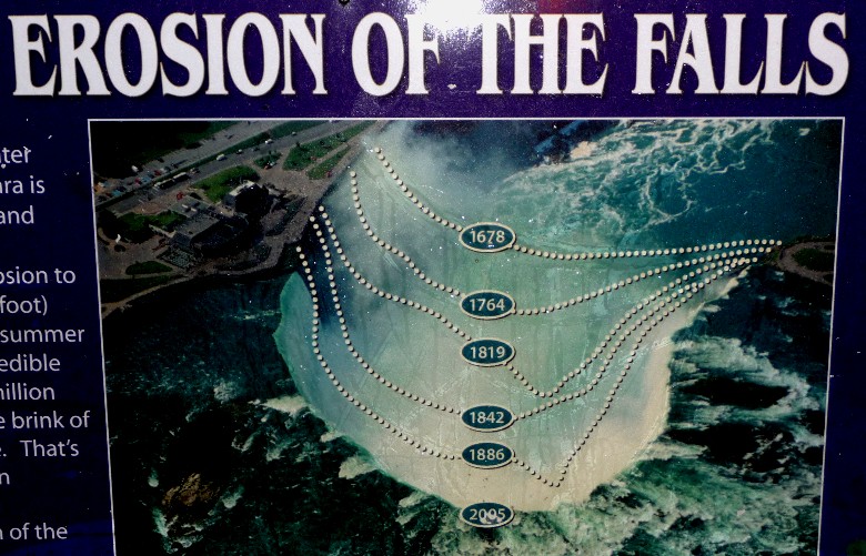
Niagara
Falls are constantly eroded and pulling back every year. This is to show how
much the Canadian Falls have eroded in the past.
ˇˇ
|